4. Yakutsk-Magadan via The Road of Bones or The Kolyma Highway - Part 1
Friday, 6 July 2007
Friday 6th July: Leaving Yakutsk late in the afternoon, we had already refuelled and restocked the pantry at the supermarket and fresh food markets. Andrey, I think, thought he was going to starve and kept suggesting more food, he is yet to realise that we are actually organised.

Just on the northern side of town is our very first challenge, getting onto the Lena River barge. There is no system and lining up was just too simple. Semi trailers, logging trucks, trucks with farm machinery, private vehicles of all descriptions and lots of small kombi like Uaz vans all jostled for loading.
Everybody starts out at being seven or eight abreast and slowly fight towards to the one lane loading ramp.
At first we were too just polite and missed the earlier barge, now we must do as the locals do. One local car cost him his indicator light fighting with my bull bar, and that did not faze him as he still pushed forward grinding his right hand guard along the bull bar to finally secure one place in front of me.
The trip to date has taken us through vast native pine country dotted with swamps and small lakes. It is summer now and the Yakutia villages are enjoying the warmth. We have been told that next week all the villages will be empty as the workers will be in the field harvesting the local grasses for winter feed. When you see the long rectangular mud barns for the domestic animals you can appreciate how hard it must be in the minus 40 and more degrees winter.
Just as we were pulling up to camp Bill’s tyre staked an old buried chisel, although quickly repaired we felt it was unbelievable.
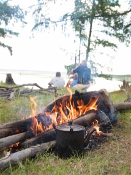
Camp was beside a beautiful lake, and an open fire....and most enjoyable as no mosquitoes.
Camp 8: Lake Camp near Village
Distance Today: 75Kms
Saturday 7th July: It is obvious that we are in the country, most of the locals wave as we drive by slowly. Their faces are weathered, again a reflection of the hostile environment, but their spirits are high. They are cattle and horse breeders, using both as meat and milk providers, and as a means of transport. The horse milk is also fermented to make an alcoholic drink of a similar strength to beer. Great importance is placed on community teamwork and high respect is held for those who have passed before them. The forbearer’s graves are ornate and hold prime position on the sides of hills overlooking the lakes, valleys and villages.

The road signs here say “Beware Everything”
At 375 kilometres from Yakutsk we arrive at the Aldan River. We decide it is too late for evening barge crossing and camped with the thousands of mosquitoes on the river bank and watch the cargo ships move up and down. The rivers in Russia are big, very big; the Lena was more than a kilometre wide and the Aldan at least half that.
Camp 9: Ferry Camp Aldan River
Distance Today: 300Kms
Sunday 8th July: Scanning back from the GPS map, it is hard to believe where we are in the world. Over 10,500kms from our home in Brisbane, on a river barge between the end of a dirt road on the South side and the small village of Kiskil on the North side of the Aldan River.
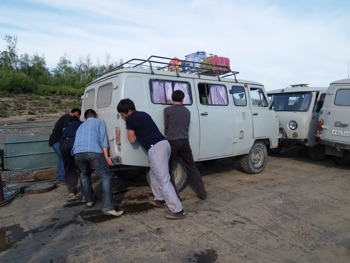
At 2000RUB(A$80) for the 2 hour, 9 Km barge trip we at first thought was expensive, but the small grey ‘Uaz’ vans, commonly referred to as a bread loaf because of their resemblance to that, were charged 1000RUB. There were 6 of them and our two trucks on the barge which seemed to operate very irregularly about every 2 hours from 6 am till 9 pm. Again we had to shuffle on the gravel river bank to retain our position, and in the end the final three Uazs that arrived late remained waiting for the next barge.
By sign language we converse with others on the barge. One of them is returning from holidays and shows us photos of his hunting and fishing expedition. He had one photograph showing himself holding two 1.25 metre Salmon fish he caught in the Aldan River just where we drove down to the barge, and another of a bear he shot ‘up country’. We think we are on an adventure, to the locals it is just a road. One young man from here was travelling further north in our direction in a 6x6 Kamaz truck for another 5 days to the oil exploration fields. He pointed to the water and indicated a height of 2 meters as being the ‘normal’ forwarding depth for the rivers ahead. Bill and I measure that on our trucks and think….. “Interesting”
We unloaded directly onto the river bank at the small village of Kiskil and then drove the 26km along a moraine gibber road west to Khandyga.
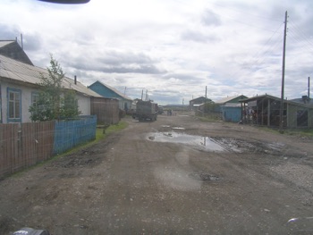
Khandyga is an old town, everything is broken, and there is junk and broken machinery everywhere. The dusty roads wind past grey timbered single story buildings, and the occasional multi story old concrete block that is slowly decomposing with concrete rot. Everywhere there are huge piles of coal just dumped at random for the winter season. One can only think that in winter at least the snow must cover all this untidiness.
We research the entire town looking for the only fuel station, finally finding it at the end of the road that follows the river bank. It is 12.05 and it is closed for lunch from 12 to 1pm.
Following topping up our supplies at the local ‘magazine’ and a potato and meat dish at the café we head out of town, refuelled for the 800km run to Susiman, the next slightly major town on the other side of track that we still have conflicting reports on weather it is actually passable
Stopping later on a concrete bridge for a ‘comfort’ stop and were soon joined by a Kamaz truck that had come from the direction we were heading. Interestingly they told us that only yesterday the river at Kyubyume was 2 meters deep and showed us the line on the Kamaz’s cab door of the water height. We knew this was not good news because this is the track we must take. We did however also know from the guys from the Shatoon 4x4 club that there may be an ice bridge we could use upstream of the main track and used for he forwarding by the small Uaz vans. We will have to make that decision when we get there.
Before we left the Kamaz driver gave us some small trout to try for dinner, and at the last minute mentioned that some Australians were camped about 70km up the road!
We knew it had to be Herb and Jessie, John and Karris that we had met in Vladivostok and set about rendezvousing with them for tonight's camp. They were from Sydney and I had been corresponding with Herb before we left home swapping contacts and ideas of our respective trips.
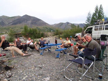
The evening was spent catching up on our travels and sharing a beer and a vodka or two or three with our new found Aussie friends.
Camp 10: Camped with some Aussies in the middle of Russia
Distance Today: 249Kms
Total Distance to Date: 3,936Kms
Monday 9th July: Leaving the Aussie reunion camp we drove along a spectacular one way track cut into the side of the near vertical cliff. 150 meters below was the fast flowing river, along its edges, and as a surprise to us were great sheets of blue ice, remnants of the last winter.
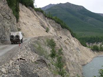
This track was hand cut into the rock by the prisoners of the Stalin era. It is not so widely known that Stalin killed over 30million of his own people during his dictatorship. Many were shipped to far flung places in eastern Siberia to build such roads. Six months was a lifetime, if you were not dead you would wish you were. Being here one still can not comprehend the hardship of the -30 and more winters, the swamps, the rain, the ice, and the plagues of mosquitoes and sand flies. Most of the villages in the area both occupied and deserted are the remains of the gulag camps.
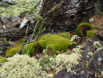
We climb over a mountain pass at 1300meters and continue to drive along the remnants of wide glacial valleys. The density of pine trees is less now and we are in more Tundra country. The ground is covered with moss and lichen and as you walk upon it, water squeezes out. In the distance are sharp pointed mountains with a dusting of icing sugar.
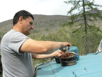
Stopping for coffee along the road and were soon joined by two Yakutians. They are forest rangers in their Russian jeep. One had a badly disfigured left eye, the reminder of an incident with a brown bear. We invited them to join us for coffee and biscuits which they greatly accepted. Soon we were presented with a small pannikin of fresh fish, which they went about salting for us. These were to be eaten raw after about two hours.
We reach the turn off to Kyubyume and Tomtor. Here the track splits, north will eventually be the new road to Magadan, as yet unfinished by 14 kilometres and a major bridge crossing yet to be constructed. East is to Magadan on the original ‘Road of Bones’.
Just after the turn off is the old broken bridge and beside it on the left is a track into the fast flowing and deep water. This was the track the Kamaz trucks have been using, very obviously not the way for us.
Back up the Yakutsk road about 500 meters was a small down hill rough track used by the local small vehicles. Following that down to the river edge we found 4 Uaz vans on this side and 6 on the other.
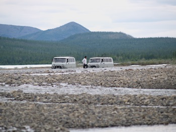
Their drivers were wading across the now very wide section of the river looking for the most appropriate line. The water was still fast but only about thigh deep. The water was freezing cold, focking painfully cold actually, because only 200 meters to the right was a huge ice shelf covering an area of at least three plus square kilometres.
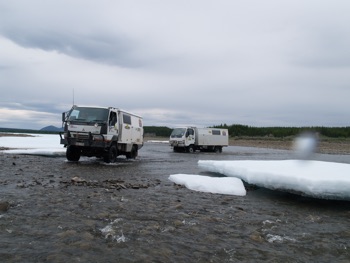
With hubs locked in, we crossed following the chosen line along the head of the rapids. This we repeated for all four crossings where the river had spread itself out across the river flood plain. The crossing was fortunately uneventful, but interesting driving across the rapids, around and through the marshy swamp areas, and between the large lumps of blue ice. To see ice was a real surprise to us all.
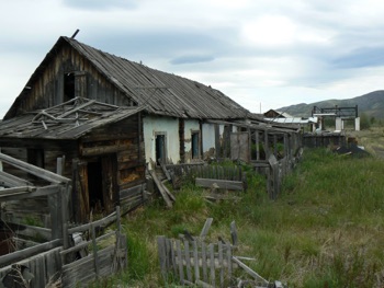
Kyubyume, on the other side was completely deserted. The houses were showing the decay of the harsh winters, and the roofs falling in from the weight of winters snow. Inside some places looked as if the occupants had just walked out.
A beanie on the back of the chair, a pair of socks on the bed, and an old cross cut saw next to the wood pile. We found the movie theatre with racks of chairs and the old projector and film on the floor. The town was picturesque but at the same time eerie.
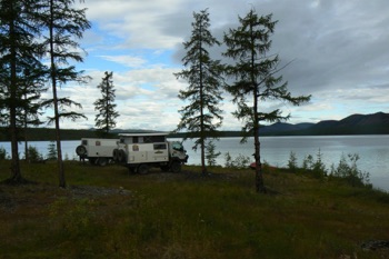
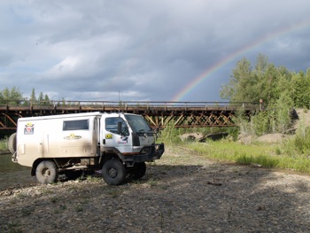
Some 28 kilometres further on, we turned left and down a small track to a beautiful lake. Our camp site was surrounded by the lake on three sides and behind us, a back drop of pine trees and multi coloured ground lichen. Across the lake the surrounding mountains were dusted with snow. This was a breathtaking camp spot.
It began to rain lightly, and the tarp was quickly erected above our mosquito enclosure. Vodka and orange juice was the drink of choice, followed by the raw salted fish. Andrey and I were the only ones to try, and in small quantities it was very nice.
Cooked it was even better!
As we fell asleep with the falling rain, we wondered how it would affect the river levels ahead.
Camp 11: Glacial Lake & Boat camp
Distance Today: 172Kms
Total Distance to Date: 4108Kms
Tuesday 10th July:
We travelled over old bridges where they existed 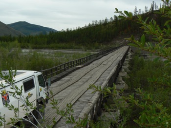 and around them where they had been washed away.
The road is more difficult today with the light rain of last night. The scenery continues to be stunning as the wide valleys stretch up to the mountains that surround us.
We reached Tomtor at around midday. This little town boasts the lowest temperature recorded on earth at minus 71.2C. Last year they recorded minus 69.5C. It is such that this is the home of the Yucatan Santa Clause. For the last six years in January there has been a festival in Tomtor when the European, Russian and Yakutia Santa Frost men meet.
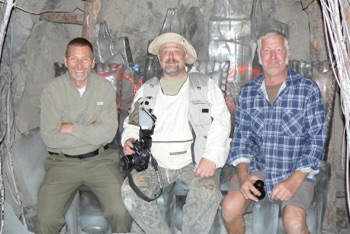
We had heard of an ice cave in Tomtor and set about finding it. It took some questioning and many ‘U’ turns to finally arrive at the ‘hotel’ behind the only fuel station about 2Kms east of Tomtor in the smaller neighbouring settlement of Cudaysung. The newly finished guest house was built of local pine timbers and proudly showed pictures of the bikers Erwin McGregor and Charlie Borman in the entrance. Not to be out done we also added our name to the walls. Following lunch of cold potatoes and meat, and best ever homemade strawberry jam and real cream, we met Vlad who would lead us to these caves.
Situated on the west side of town were two of what I had first thought were deserted gold mines. These mines were tunnelled into the only hill that overlooks the town but they were not mines but the town’s refrigerator.
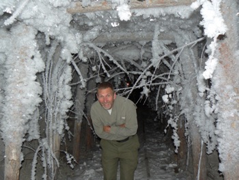
Dug many years ago, the frozen permafrost below the ground surface provides a natural freezer in which to store the towns supplies collected in summer to be accessed during the long winter. The inside of the tunnels is a constant minus 15C, Vlad added that in winter it is actually warmer inside than outside. One of these tunnels has been converted to be the world’s only natural ice carving museum. The ice carvings depicted the Yakutia Santa Clause and other legends and animals of the Yakutia culture.
Following refuelling at the antiquated fuel pumps at Cudaysung we head out of town.
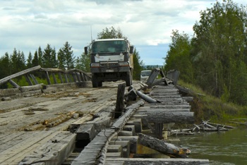
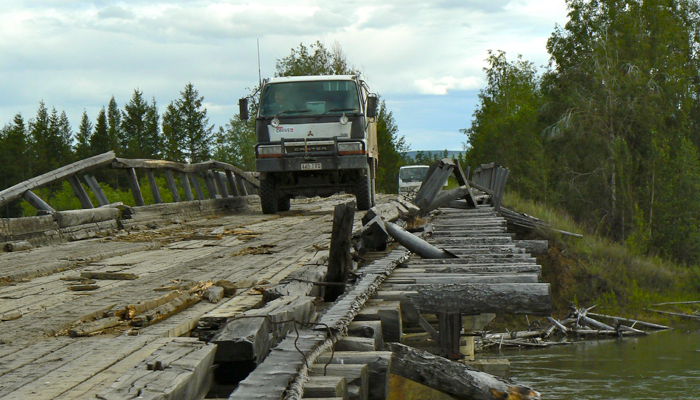
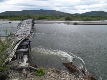
About 25 km out we cross an only just standing log bridge, it has been constantly repaired but nature and the pull of the fast and mighty river is slowly winning. I think it will be lucky to last another season; my fear is that once this and the other such bridges are gone so has access to this historic road.
From here on the road becomes a track. There is now grass growing down the centre line and shows all but no maintenance, other than for rocks or logs dropped into washouts by other travellers such as ourselves.
We camp about 40km out, in the stony flood plain of a creek.
Camp 12: Fast River Bridge Camp
Distance Today: 217Kms